


Global Positioning System (GPS)
What is Global Positioning System (GPS)?
The Global
Positioning System (GPS)
is a space-based satellite navigation system that provides location and time
information in all weather, anywhere on or near the Earth, where there is an
unobstructed line of sight to four or more GPS satellites. It is maintained by
the United States government
and is freely accessible to anyone with a GPS receiver.
The GPS program provides critical capabilities to
military, civil and commercial users around the world. In addition, GPS is the
backbone for modernizing the global air traffic system.
The GPS project was developed in 1973 to overcome
the limitations of previous navigation systems, integrating ideas from several
predecessors, including a number of classified engineering design studies from
the 1960s. GPS was created and realized by the U.S. Department
of Defense (DoD) and
was originally run with 24 satellites. It became fully operational in
1994.
Advances in technology and new demands on the
existing system have now led to efforts to modernize the GPS system and
implement the next generation of GPS III satellites and Next Generation
Operational Control System (OCX). Announcements
from the Vice President and the White House in 1998 initiated these changes. In
2000, U.S. Congress authorized the modernization effort, referred to as GPS
III.
In addition to GPS, other systems are in use or
under development. The Russian GLObal NAvigation Satellite System (GLONASS)
was in use by only the Russian military, until it was made fully available to
civilians in 2007. There are also the planned European Union Galileo
positioning system, Chinese Compass
navigation system, and Indian Regional
Navigational Satellite System.
Basic Concept of GPS
A GPS receiver calculates its position by precisely timing
the signals sent by GPS satellites high above the Earth. Each satellite continually
transmits messages that include
§
the
time the message was transmitted
§
satellite
position at time of message transmission
The receiver uses the messages it receives to determine the
transit time of each message and computes the distance to each satellite using
the speed of light. Each of these distances and satellites' locations define a
sphere. The receiver is on the surface of each of these spheres when the
distances and the satellites' locations are correct. These distances and
satellites' locations are used to compute the location of the receiver using
the navigation equations. This location is then
displayed, perhaps with a moving map display or latitude and longitude;
elevation information may be included. Many GPS units show derived information
such as direction and speed, calculated from position changes.
 In typical GPS operation, four or more satellites must be
visible to obtain an accurate result. Four sphere surfaces typically do not
intersect. Because of this we can say with confidence that when we solve the navigation equations to find an intersection, this solution gives us the
position of the receiver along with accurate time thereby eliminating the need
for a very large, expensive, and power hungry clock. The very accurately
computed time is unused in many GPS applications, which use only the location.
A few specialized GPS applications do however use the time; these include time transfer,
traffic signal timing, and synchronization of cell phone base stations.
In typical GPS operation, four or more satellites must be
visible to obtain an accurate result. Four sphere surfaces typically do not
intersect. Because of this we can say with confidence that when we solve the navigation equations to find an intersection, this solution gives us the
position of the receiver along with accurate time thereby eliminating the need
for a very large, expensive, and power hungry clock. The very accurately
computed time is unused in many GPS applications, which use only the location.
A few specialized GPS applications do however use the time; these include time transfer,
traffic signal timing, and synchronization of cell phone base stations.
Although four satellites are required for normal operation,
fewer apply in special cases. If one variable is already known, a receiver can
determine its position using only three satellites. For example, a ship or
aircraft may have known elevation. Some GPS receivers may use additional clues
or assumptions such as reusing the last known altitude, dead reckoning, inertial
navigation, or including information from the vehicle computer, to
give a (possibly degraded) position when fewer than four satellites are visible.
GPS in Three Stages
Stage 1 – The satellites act as reference
points.
The
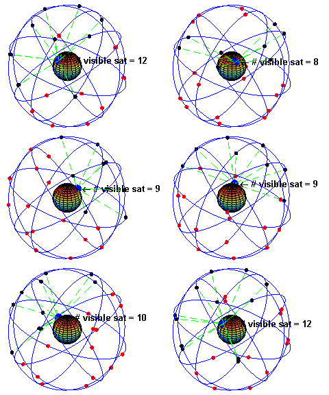
nominal GPS Operational Constellation consists of 24 satellites at an altitude
of 20,100 km (12,500 mi) and with a period of 12 hours. The satellite orbits
repeat almost the same ground track (as the earth turns beneath them) once each
day. There are six orbital planes with nominally four satellites in each,
equally spaced (60 degrees apart), and inclined at about 55 degrees with respect
to the equatorial plane to ensure coverage of Polar Regions. This constellation
provides the user with between five and eight satellites visible from any point
on the earth. Powered by solar cells, the satellites continuously orient
themselves to point their solar panels toward the sun and their antennas toward
the earth. Each satellite contains four atomic clocks.
The
orbital motion of each one is monitored by the Master Control facility located
at Schriever Air Force Base (formerly Falcon AFB) in Colorado. The Master
Control station computes precise orbital data (ephemeris) and clock corrections
for each satellite. It uploads ephemeris and clock data to the satellites. The
satellites then send subsets of the orbital ephemeris data to GPS receivers
over radio signals. The control segment also ensures that the GPS satellite
orbits and clocks remain within acceptable limits. These precise positions and
data form the basis for all GPS calculations.
Stage 2 – The signal travel time gives distance
information.
GPS
satellites carry atomic clocks that provide extremely accurate time. The time
information is placed in the codes broadcast by the satellite so that a
receiver can continuously determine the time the signal was broadcast. The
signal contains data that a receiver uses to compute the locations of the
satellites and to make other adjustments needed for accurate positioning. The
receiver uses the time difference between the time of signal reception and the
broadcast time to compute the distance, or range, from the receiver to the
satellite. The receiver must account for propagation delays, or decreases in
the signal’s speed caused by the atmosphere. To calculate the distance between
itself and any given satellite the receiver multiplies the travel time by the speed
of light. This principal is fundamental to GPS.
Stage 3 – Three distances gives the position.
Once
stages 1 and 2 have been accomplished we now have distance information to a
number of satellites the locations of which we know with great precision. From
this data, the receiver triangulates an exact position. Three satellites are
needed to determine latitude and longitude, while a fourth satellite is
necessary to determine altitude. An atomic clock synchronized to GPS is
required in order to compute ranges from these three signals. However, by
taking a measurement from a fourth satellite, the receiver avoids the need for
an atomic clock. Thus, the receiver uses four satellites to compute latitude,
longitude, altitude, and time.
Explanation
Let’s
assume that the receiver determines that it is 20,000km from a particular
satellite. This means that the receiver could be anywhere on an imaginary
sphere with the satellite as its centre. If it also determines that it is
25,000km from a second satellite this narrows its location down even further.
The only location in space where it can be both 20,000km from the first
satellite and 25,000km from the second is where these two spheres intersect.
That intersection is a circle of points. A third measurement adds another
sphere which intersects the circle formed by the first two. This intersection
occurs at two points, and so, with these three measurements, the GPS receiver
has narrowed down its location to just two points in the entire universe.

A fourth measurement will intersect exactly
with one of the two points. In practice, however, you may not need this fourth
measurement as one of the two points will normally be located thousands of
kilometres out into space, and therefore is unlikely to be your position!
However a fourth measurement is used to calculate altitude. It also ensures
that the receiver’s clock is truly synchronised with universal time.
Although
this example demonstrates the use of four satellites, many receivers are
capable of tracking more than four satellites at a time. In some cases
this improves the positional accuracy of the receiver.


